Newsletter Subscribe
Enter your email address below and subscribe to our newsletter
[forminator_form id="25163"]

All voices matter
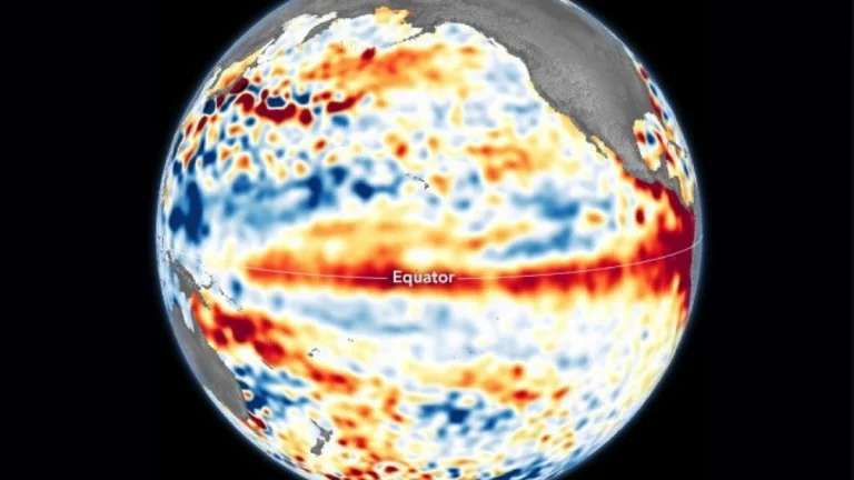
newsweeknewsweekabcA rapidly intensifying El Niño is barreling toward what could become one of the strongest such events in recorded history, prompting warnings from climate agencies and insurers alike as the tropical Pacific warming accelerates at an unprecedented pace.
NOAA's Climate Prediction Center reported on July 9 that the current El Niño has continued to build, placing an 81 percent chance of a "very strong" event between October and December 2026 and a 97 percent chance it persists into early spring 2027. Australia's Bureau of Meteorology noted that sea surface temperature anomalies have surged from around -1°C at the start of the year to nearly +2°C by late July — the fastest El Niño development since 1900 — with models projecting the Niño 3.4 index could reach approximately +3.5°C by mid-to-late spring, far exceeding any previous record.newsweek+2
Munich Re on July 30 warned of a "dangerous mix" as climate change compounds the intensifying El Niño. "As global warming continues, the world is also heading for a Super El Niño, which will drive temperatures up even further," said Tobias Grimm, the company's chief climate scientist. "The effects will likely be clearly felt in the second half of the year."kelo
The reinsurer said natural disasters caused worldwide losses of nearly $112 billion in the first half of 2026, of which only $44 billion were insured. Looking ahead, Munich Re's board member Achim Kassow said "Asia-Pacific is likely to be the region which will suffer most from El Niño," citing higher typhoon risk in Japan and Korea alongside heatwaves, drought and wildfires in Southeast Asia, India and Australia.straitstimes
Forecasters say the atmospheric response is already visible. July pressure and temperature patterns across North America closely match those observed during previous Super El Niño events, with a warm ridge over the central and eastern United States and cooler conditions along the West Coast.severe-weather
For the United States, NOAA projects above-normal precipitation across much of the southern tier during fall and winter. "The highest probabilities for above-normal precipitation are over the Gulf States and parts of the Southeast to Mid-Atlantic," said Johnna Infanti of the Climate Prediction Center. States including California, Florida, Georgia and Mississippi face elevated risks of heavy rainfall, flooding and severe weather.newsweek
In Australia, the Southern Oscillation Index has plummeted to nearly -30 — its lowest in over four decades — signaling disrupted trade winds and sharply declining rainfall. The Bureau of Meteorology's seasonal forecast through October points to reduced precipitation across eastern states and elevated bushfire risk.abc
Climate scientist Zeke Hausfather wrote on July 30 that his forecast model now places 2026 global temperatures at 1.50°C above pre-industrial levels, with strengthening El Niño forecasts accounting for 84 percent of the upward revision in odds that 2026 sets a new annual temperature record. NOAA's Geophysical Fluid Dynamics Laboratory reported that all 30 members of its experimental SPEAR forecast ensemble project a very strong El Niño peaking later this year, with every member reaching intensity competitive with the strongest events observed over the past century.theclimatebrink+1
"Current forecasts point to record-breaking El Niño conditions towards the end of the year," Munich Re stated, as emergency managers, water agencies and weather offices across vulnerable regions prepare for what could be the most consequential climate event in decades.kelo