Newsletter Subscribe
Enter your email address below and subscribe to our newsletter
[forminator_form id="25163"]

All voices matter
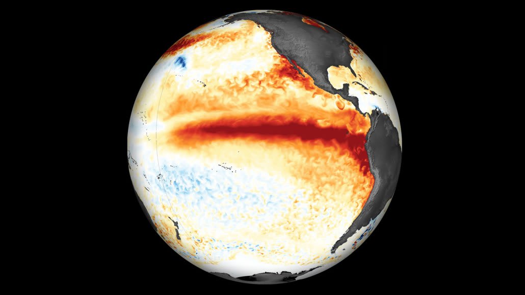
yourweather.co.uk.public.wmo.int.sfchronicle.com+1.El Niño has crossed into the "very strong" category. The relative anomaly in the central Pacific reached +2.0°C for August through October, according to an analysis by Meteored based on the criteria used by the US National Oceanic and Atmospheric Administration. The warming is not finished yet. The World Meteorological Organization (WMO) projects that sea surface temperatures in the tropical Pacific may rise to 3.8°C above average from November 2026 to January 2027, with the peak expected in December.yourweather.co.uk+1
"This is literally off the monitoring charts that we have used for the past four decades," WMO Secretary-General Celeste Saulo said. She added that El Niño "will peak towards the end of 2026 but its impacts will be felt long after that".public.wmo.int
The +2.0°C figure comes from NOAA's Relative Oceanic Niño Index (RONI), which NOAA began using in February 2026. The index removes background warming across the tropical oceans. Under the older Oceanic Niño Index, the event had already reached very strong levels in July through September, at +2.2°C, and rose to +2.5°C for August through October. The WMO's 3.8°C projection uses the conventional anomaly. Meteored estimates it could equal roughly +3.2°C to +3.4°C on the relative scale.yourweather.co.uk
NOAA's Climate Prediction Center says a strong-to-very-strong El Niño is likely through January–March 2027. It also puts a 70% chance on a historic event for November–January, meaning one stronger than any since 1950. A WMO regional update warned of drier months across much of the western Pacific and said there is "a high chance" this will be the strongest El Niño on record since 1950.wmo.int+1
California's outlook is wet. All 51 runs of the European Centre for Medium-Range Weather Forecasts' seasonal model, released November 5, call for a wetter-than-normal December through March around San Francisco, the San Francisco Chronicle reported. The average forecast is about 26 inches of rain, nearly double normal. January is expected to be the wettest month, with more than 8 inches.sfchronicle.com
Unusually warm coastal water adds to the risk. The model expects ocean temperatures off California to peak 10 to 13 degrees Fahrenheit above normal in December. That would put water near San Francisco close to 67 degrees instead of the usual 54. Warmer water can give incoming storms more moisture.sfchronicle.com
NOAA's winter outlook also favors wetter-than-average conditions across the southern US, from California to Florida, and a warmer-than-average northern tier.noaa.gov
Elsewhere, the WMO outlook points to drier conditions in southern Africa, rainfall shortfalls in Southeast Asia and a higher drought risk in Central America and the Amazon. Saulo said a powerful El Niño "does not have to be a recipe for humanitarian disaster," and called for "decisive action, especially to protect the most vulnerable communities."public.wmo.int